I said my data was taken with ADR. Where did i say they were from fast moving measurements?
Note that most field mappers of course offer ADR, as it makes good sense.
For mobile/fast-moving mapping, i suggested fixed SF7 - that, not ADR, was what the whole thread was about. If we suggested ADR, we wouldn’t have to discuss SF.
I offered my data as they are mostly from dense urban environments, so it s fair to assume some similarity to the asker’s situation.
The asker’s situation was that high SF wasn’t giving any results, in a “driving round” scenario. So going shorter makes a lot of sense, not least cos you are allowed to send more than just 3 or 4 points an hour.
You obviously did not collect 190,000 distinct points with fixed nodes.
But then when asked if you had used ADR, you confirmed that you had.
Therefore it seems you were making the invalid experiment of moving an ADR node around fairly quickly compared to the timescale at which ADR operates.
No, it is not fair to assume that AT ALL.
Where gateways are compared to where you are trying to get signal from, has absolutely nothing to do with where gateways are compared to where the asker is trying to get signal from.
If we suggested ADR, we wouldn’t have to discuss SF.
ADR still results in an SF. If one left a node in place long enough for ADR to stabilize, then absent gateway changes or construction blocking the line of site, the long-term stable ADR result would be a good choice for a static SF, too.
But the result of moving an ADR node around on a timeframe of less than days isn’t meaningful.
The asker’s situation was that high SF wasn’t giving any results, in a “driving round” scenario. So going shorter makes a lot of sense, not least cos you are allowed to send more than just 3 or 4 points an hour.
That may be true.
But your offered data is useless for determining so.
The comparative lack of mid-range SF’s in your data calls its validity for even your situation into serious question.
That EUI looks a bit dodgy, like someone just made it up.
Still weird that you can are received by that one, and not others.
EDIT: I can find the following information for this EUI on https://www.thethingsnetwork.org/gateway-data/ :
“eui-0908070605040302”:{“id”:“eui-0908070605040302”,“description”:“Boltenburg Unternehmensgruppe, Standort Remscheid, Service-Line: 0700 - 80 80 80 08”,“owner”:“hartmut-boltenburg”,“owners”:[“hartmut-boltenburg”],“location”:{“latitude”:51.18321709,“longitude”:7.22158692,“altitude”:398},“country_code”:“de”,“attributes”:{“antenna_model”:“Procom CXL 900-3LW-NB / 868 MHz mit 32m Koaxkabel LCF 78/50”,“brand”:“Four-Faith”,“frequency_plan”:“EU_863_870”,“model”:“F8L10GW EU 868”,“placement”:“outdoor”},“last_seen”:“2020-09-29T11:19:55Z”}
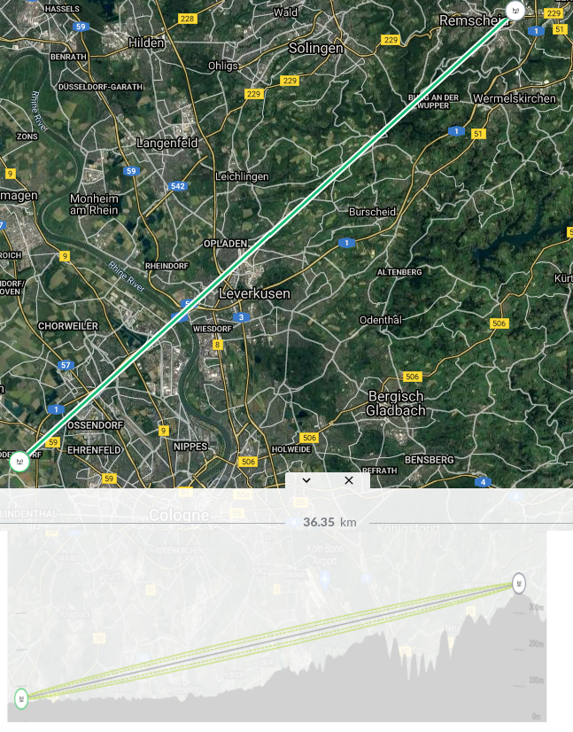
The gateway of the Boltenburg Group near Remscheid is abt 300m MSL high. It looks from above down to the river Rhein. It should be no problem to “see” this gateway from the west of Cologne. This gateway has a huge coverage.